
HiiLSE Drone · Solutions
Construction Industry Drone
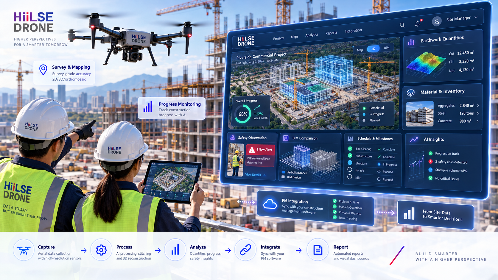
Construction intelligence combining drone mapping, progress capture, quantities, computer vision, material/inventory insight, safety evidence, project-system integration and human advisory.
HiiLSE Dynamic Solution Intelligence
Interactive · Hover / TapDrone → Construction Intelligence → PM / BIM / ERP
Aerial capture becomes project intelligence only when data, AI, human validation and project systems are connected.
Select a mission stage
Hover, focus or tap a stage to examine its role in the HiiLSE end-to-end solution.
Verified Positioning
World’s #1 · 360° Construction Industry Automation Advisory
Hardware & software independent · Drone · AI · BIM · ERP · PM integration · sensing · robotics · qualified human advisory.
Approved HiiLSE Construction Visuals
Smarter Construction from Above
Unique HiiLSE visual design connects the flying platform, construction site, AI/data processing and project-management command view.

Drone → PM Software Integration
Move Evidence from the Site into the Project Workflow
The objective is not “a drone photo”. The objective is structured evidence that supports project control, survey, engineering, BIM, ERP and management decisions.
Drone capture- Progress packageReady for PM report
- Quantity evidenceSurvey validation
- Site observationIssue workflow
- Historical comparisonCurrent vs baseline
Interactive Public Experience
HiiLSE Drone Construction Simulation Workstation
Move the simulated drone, change location and camera view, watch predefined GPS/telemetry values respond, trigger AI/computer-vision detections, and follow the workflow into qualified human review and decision/reporting.
8-minute scenarioJoystick + buttonsAI detectionsFullscreen
SIMULATION · Simulation Mode — telemetry, AI findings, quantities, progress, safety and PM/BIM/ERP data shown are predefined/illustrative for demonstration and training purposes.
Construction Solution Library
Construction Solution Library
Read the HiiLSE construction solution as a PDF scroll experience or as a slide-by-slide presentation viewer.
Construction HiiLSE Drone Solution · PDF
Read inside a controlled HiiLSE viewer with page, zoom, fit-width and fullscreen controls.
Construction HiiLSE Drone Solution · PowerPoint
Browse rendered slides with previous/next controls, thumbnails, autoplay and fullscreen. The original PowerPoint remains available.
World’s #1 · 360° Construction Industry Automation Advisory
Verified HiiLSE positioning: hardware- and software-independent construction technology advisory connecting drones, sensing, AI, BIM, ERP, project-management software, robotics, data and qualified human expertise around the project requirement.
Drone → PM / Construction Software Integration
Drone imagery, orthomosaics, point clouds, terrain models, quantities, progress observations and selected AI findings should not remain isolated. HiiLSE structures approved outputs so they can support project tasks, issues, reports, BIM/ERP records, schedule/progress evidence and management decision workflows.
Progress, Quantities & Historical Comparison
Repeated surveys can support cut/fill and stockpile measurement, progress comparison, site documentation, material/inventory observation and historical evidence across project stages.
AI Material, Safety & Site Intelligence
Where suitable, computer vision can assist with selected material/equipment counts, progress observations and safety evidence. AI outputs remain subject to project-specific quality controls and qualified human/engineering validation.
Interactive Construction Workstation
Launch the full-screen simulation to move the drone, change project locations, switch between bird’s-eye, FPV, side, BIM/wireframe and point-cloud views, observe simulated GPS/RTK/battery data and see construction AI/PM metrics change over a predefined 8-minute scenario.
Construction Solution Library
Read the approved HiiLSE construction solution PDF in scroll mode or browse the supplied PowerPoint as a slide-by-slide web viewer with thumbnails, page count, full-screen and downloadable source files.
HDcms Document Experience Standard
Full-Width · Device-Responsive · Voice-Controlled Reading
PDF and presentation viewers use the full available width, adapt to desktop/tablet/mobile height, and support voice commands where browser speech recognition is available.
Voice commandsNext pagePrevious pageFirst pageLast pageZoom inZoom outFull screenClose full screen
Free Resources & Continue
STANDBYConstruction Drone solution resources
Executive brief, technical pack and project assessment delivery channels are prepared for governed publication.
Standby actions remain visible for planning but never open a broken or unfinished asset. Published resources become active only after CMS approval.