Capabilities
Aerial survey; orthomosaic; photogrammetry; 3D modelling; DEM; DSM; LiDAR; point cloud; terrain; contours; volumetrics; digital representation; GIS; progress comparison.
 People · Technology · Possibility
Mission planning, aerial capture, photogrammetry, orthomosaic, terrain/elevation data, point clouds, GIS outputs and human interpretation according to required accuracy and project objective.
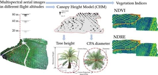
Aerial survey; orthomosaic; photogrammetry; 3D modelling; DEM; DSM; LiDAR; point cloud; terrain; contours; volumetrics; digital representation; GIS; progress comparison.
View, print, share or request approved HiiLSE resources for this page as they become available.
Standby actions remain visible for planning but never open a broken or unfinished asset. Published resources become active only after CMS approval.